|
 SOUNDTRACK SOUNDTRACK
FILMING LOCATIONS
TRIVIA
GOOFS
MISSING SCENES
Truman Sparks: "Hey listen dude, if you're
into playin' it close that's cool, but we're talkin' major malfunction
here!" |
|
FILMING LOCATIONS
This section is primarily constructed from information
and photos sent in by Bill Peterson after his August '03 Fandango road trip
(thanks Bill!). There's also a great site detailing the Fandango movie
locations at
www.central70.org/Fandango/Sites.html, including location
maps.
On this page:

Toyah School (Frat House and
Restroom?) |
|
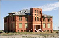
Bill Peterson:A couple of internet posts
suggest that the frat house and restroom scenes where shot on a set built in an
abandoned school in Toyah, Texas. I stopped by to check it out. The building is
easily the biggest building in Toyah, and it must have been quite beautiful in
its' day. The building obviously has not been used in a long time, and it is
dilapidated and with all of the doors and windows boarded. I ignored the
"posted - no trespassing" sign, and managed to squeeze through a crack in the
plywood to explore the basement. |
|
zoom-in
|
It was pretty creepy, with remnants of several dead
animals scattered around in the dark rooms. There was a staircase leading up to
the first and second levels, but it was dark up there so I chickened out. So,
anyone with a good flashlight and a sense of adventure can go check it out. I
tried to learn more about the school, but I literally could not find one person
in the city. It really is a ghost town. A
Toyah website indicated that the second floor of the school
was converted to a gym in the 1960's - I bet the sets were located there. The
school is located on the Northern side of town - you can't miss it. GPS
coordinates: N31º 19.000', W103º 47.569'.
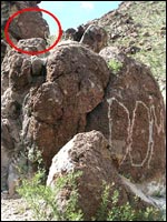
Jerry Bandy, Watauga, Texas: I visited a web site about
Toyah, Texas and came across a picture of an abandoned school
that may have been used as a set in Fandango. It was listed that
the only sets were for the bathroom scene and the frat party scene.
The picture was taken by Jason Penney. The website is www.texasescapes.com/TOWNS/Toyah_Texas/Toyah_Texas.htm
(scroll down to 'Toyah Elementary and High School').
Man it's amazing what some of these old folks remember.....the
architect and builder was Albert Bruce. The schools in Pyote and
Royalty are supposed to be exactly the same as Toyah's and designed
and built by him. The lady that knew this was a granddaughter
of Albert Bruce.
fandangoJeff
Site of the McLean Massacre
Read Buzz
and Jessica's full story on our FAN'S STORIES page
|
|
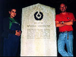
Buzz: We made it to the site of the McLean
Massacre. We got there after dark, but got a photo of me and one of my
daughters standing next to the marker. It is nothing like the one in the movie.
It also is in a completely different location than shown in Fandango. This
marker was beside a two-lane, paved county road, in the piney woods of east
Texas, about 10 feet off the road in someone's front yard. The piney woods is
an area of rolling hills forested with very tall pine trees and dense
underbrush. This makes me wonder a few things: |
- Why did Kevin Reynolds select such an
historically obscure marker, from the middle of nowhere Texas? (the neares
towns are Elkhart and Slocum. Each have populations under 2000).
- Did he have the marker shown in the movie
made, or did he buy it from the state when the latest marker was erected?
- Where was the location shown in the film? I
want to go there as well.
We plan a Fandango of our own and want to hit
as many of the sites as possible. If there's any way you can get the answers,
I'd love to hear them. Do you have any contact information for Kevin Reynolds?
Once I finish the roll of film, I'll scan and send images of the current marker
to you. The text is as shown in the movie, but engraved into a stone tablet
about 5 feet tall.
Alex: Unfortunately I have no contact info for
Kevin Reynolds (I've no idea if he is on the web or knows of this site's
existence), but I shall forward your mail to Chuck in case he has any
info...
Dustin L. Campbell: I noticed that there is some confusion as to the
location of the "McClean Massacre" scene in the movie. I will only add to the
confusion with my findings. The official Texas Historical Commission Texas
Historical Marker Atlas database (atlas.thc.state.tx.us)
lists the McClean Massacre Historical Marker near Palestine, Texas, which is in
the Northeast Texas Pineywoods - far removed from the West Texas landscape in
the movie setting by about 500 miles.
I can't recall the
exact spelling or the text of the Historical Marker in the movie. My search was
only for "McClean". The database does allow for searches of phrases, etc. of
the Marker full text so I will try to watch the movie again and search the
database using some unique keywords from the Marker text to see if we can get a
match (or one of the Fandango Fans can do it as I am busy these days). If we
can find the exact marker, the database will provide directions to the
site.
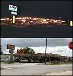
Sonic
Drive-In
Tim Parsons (El Chango Borracho Studios):
There seems to be a lot of controversy on your site concerning just where the
Sonic is located. Let me clear that up: it's the Sonic in Alpine, TX. My older
brother, Brent and his girlfriend (and future wife), Laura were extras on
"Fandango" for this scene. Laura was picked to get in a car and make out with
another extra. My brother, who was also there as an extra, stepped up and let
it be known that if anyone was going to be making out with Laura, it had better
be him, her boyfriend. Exceptions were made, and, you guessed it, Brent and
Laura are the couple making out in the car that Dorman is stealing fries from
in the film. They now live outside of Austin and show the video to their kids
as "mom and dad's romantic film debut". They will get a kick out your site and
especially some long overdue, um, "acting credit"...
Not only did I know people involved in that scene
(including Mr. Bill "...two chili dogs and a malt" Evridge, the father of a
classmate of mine), but I watched it being filmed from across the street that
evening with the members of my inebriated softball team. I can remember
watching them do several takes of what looked like the Groovers arriving (on
foot) at the Sonic with Dorman carrying Lester over his shoulder (do you ever
see Lester's carcass anywhere in the Sonic scene or during the highjinks
after?? Hmmmmmm). This was all before Costner was anybody and Nelson was still
a year away from becoming a "Brat Pack"er. Still, having the one-way blocked
for a Hollywood film was a big deal in little Alpine TX....
Bob's Older Brother: The sonic in Alpine was the
drive-in used in the movie. I was there while they were filming it and got laid
by one of the girl extras in the cruising scene.
Mitch London: The sonic where they pick up the
girls was shot in Alpine, TX. I should know I lived there for 7 years and the
sonic is still in the same location to this day and is open for business.
|
Bill Peterson: The Sonic
drive-in, that supposedly is in Marfa, Texas, is actually in Alpine, Texas. The
Alpine Visitor's Center confirmed that the filming occurred there in 1983. The
Visitor's Center suggested that the library at Sul Ross University may have
information on the filming in their archives. I paid them a visit, and all they
could offer was a full year of the "Alpine Avalanche" newspaper on microfilm
with the suggestion "there's probably an article in there somewhere". I'll
leave it to a more diehard Groover-wannabe to do that piece of research. The
Sonic is located on the corner of E. Holland and N. Garrett streets in downtown
Alpine. GPS coordinates: N30º 21.530', W103º 39.385'. |
|
zoom-in
|
|
|
|
Swede: Photo from
my 2005
location-hunt road trip.
(Click on thumbnail to zoom
in.) |
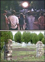
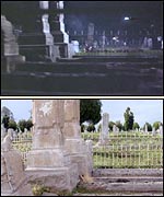
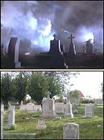
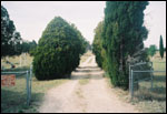
The Cemetary
Mitch London: A friend of mine
insists the fireworks graveyard scene was shot at the Marfa
cemetery.
Bill Peterson: Mitch's friend is right; I found the
cemetary in Marfa and was able to correlate several of the photos I took with
scenes from the movie. I could find no one in town who knew anything about the
movie, so I could not get any further details. I could not find the headstone
of "Cpl. Charles T. Soloman (the grave marker shown in the movie), so I assume
that it was a prop. The cemetery (named "Cementerio de la Merced") is located
on the western edge of Marfa, about a mile from the center of the city, on
Highway 90. GPS coordinates: N30º 18.474', W104º 02.357'.
|
|
|
Swede: Photo from my
2005
location-hunt road trip.
(Click on thumbnail to zoom
in.) |
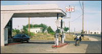
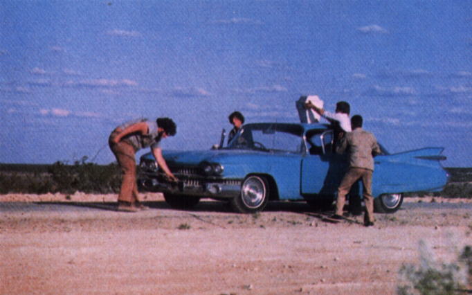
The Gas Station
Tim Parsons (El Chango Borracho Studios):
This might clear up some confusion is the actual location of the gas station
where the Groovers get Phil's car patched up. The scene is supposed to be
taking place in Marfa, but the actual gas station where they filmed it is in
Marathon, TX. I know this because I took some friends down to Big Bend National
Park on a camping excursion (I now live in Dallas) in early 2000. There are two
entrances to the Park, one through Alpine, and one through Marathon. We were
exiting the park via the Marathon route and stopped at a gas station there.
I started realizing how familiar the place looked, and on
further inspection inside the place, noticed that they had a wall full of old
photos taken of the (Fandango) filming that had occurred there 16 yrs previous.
When I inquired about it, I got a slew of anecdotes from the now very animated
proprietor. It was cool to note that, after all that time had passed, the guy
still gets excited reliving it and telling the stories. This was a couple of
years ago now, but as far as I know, the station is still operating on the main
Hwy (90) through town in Marathon, looks much the same, and has a great wall
full of many behind-the-scenes shots.
|
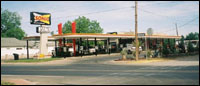
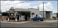
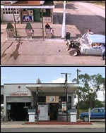
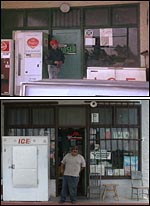
Bill Peterson: Just like the Sonic, the gas
station that is supposed to be in Marfa is actually in another city - Marathon,
Texas. The gas station is still in operation and hasn't changed too much. The
car wash (wherePhil gets a bath) is still behind the station, but no longer in
operation. The owner of the station said the gas station and car wash scenes
were filmed in a single long day, with many curious residents crowded around to
watch the action. |
|
zoom-in
|
|
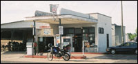
Just like the Sonic, the gas station that is
supposed to be in Marfa is actually in another city - Marathon, Texas. The gas
station is still in operation and hasn't changed too much. The car wash (where
Phil gets a bath) is still behind the station, but no longer in operation. The
owner of the station said the gas station and car wash scenes were filmed in a
single long day, with many curious residents crowded around to watch the
action.
The owner (shown right in the bottom photo,
beneath the still from the film) was actually part of the filming - he was
hiding inside the station, and after each take he would unlock the front door
to allow the actor portraying him to come back inside the station for another
take. When I asked him when the filming occurred, he pulled out the original
agreement that he had with Warner brothers. It was dated "2/22/83", and
specified that filming would take place in "May, 1983".
Warner Brothers paid him $200 for the use of his
station ($200 was the estimated amount of revenue he ost by closing his station
for a day). There's a single, faded-out Polaroid picture of Costner with his
arm around the owner of the gas station on display inside. Incidentally, the
shooting of this scene was originally scheduled for an old Texaco station in
Marfa, but that building was destroyed before the scene could be filmed. The
location scout found this similar gas station in Marathon. The gas station is
located on Highway 90 at Avenue F in Marathon. GPS coordinates: N30º
12.369', W103º 14.608'. |
|
zoom-in
zoom-in
|
|
|
|
|
|
Swede: Photos from my 2005
location-hunt road trip. |
The Giant Set
Tim Parsons (El Chango Borracho Studios): I
really don't think that anything much has remained of the old "Giant" Reata
movie location for quite some time, even in the early '70's when "Fandango" was
set. I have a friend who owns an old photo of the facade when it was still
barely recognizable as a house, but decayed and falling to pieces and I think
it's circa the early/mid 60's. Nowadays there's only some random lumber from
the scaffolding visible in the distance from the Hwy, but that's it. For those
making a pilgrimage, the remains can be found between Marfa and Valentine, TX
on Hwy 90 approx 10 miles east of Valentine looking south (it's about 35 miles
between Marfa and Valentine... that means the Groovers would've had to walk 25
miles out of Marfa to crash at the old Giant set and then the same amount to
get back the next morning.... quite an amble).
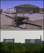
Pecos Parachute School
Chuck 'Dorman' Bush: I'm going to have to knock out
some of the cobwebs in my head, but I believe that the Parachute School as at
Rattlesnake Air Force Base in Toya, Texas.
Jay Shinn: Your site
mentions that Rattlesnake Airforce Base is in Toya, TX. I believe that it is
(or was) located in Pyote, TX and I think that it is now a minimum security
prison.
Steve Berry: The Pyote airbase (where the Truman's hanger
is) was used after the war as a storage facility for surplus aircraft and the
Enola Gay was kept there after the war before being sent to the
Smithsonian....only a part of the old hanger remains today & is on state
land its on the west side of the old base and about 1/4 mile south of I-20,
approach at your own risk.
I grew up & still spend quite a bit of time
in the areas where this movie was shot and used to run around and hunt on the
old airbase at Pyote... also been around the bigbend area where more scenes
were shot... many of the people in Alpine that were in the movie still live
there.
|
Bill Peterson: Driving down
Interstate 20 in West Texas, no one would guess that the concrete ruins rising
up from the scrub brush were once an air force base, much less the setting of
one of the funniest scenes ever filmed. The Pecos Parachute School, aka
Rattlesnake AFB, aka Pyote Air Force Station has been reduced to a concrete
shell of what once was a large airplane hanger. Truman would be disappointed to
learn that no resort development has happened yet. The
West
Texas State School (a fairly intimidating-looking "secure juvenile
detention facility") has been built on the eastern edge of the property, at
least a half mile from the hangers. I struck up a conversation with one of the
guards at the facility - he said that he was living at the base while the movie
was being filmed, and his father actually worked security on the set. |
|
zoom-in
|
He said that the film crew was onsite for almost two
months to prepare the site and do the filming. He also confirmed that the
concrete pillars visible from the highway are indeed the remnants of the hanger
where the movie was filmed, and where the Enola Gay was once stored. The
remains of the hanger are about ½ mile south of the interstate, and I
would have ventured out for a closer look if it were not for my dislike of
rattlesnakes and imprisonment (the tarmac is now used for Texas Department of
Public Safety training, according to the guard). There are some good close-up
photos of the hanger available on this
Abandoned Airfields site. To get to the location, take the
Pyote exit off of Interstate 20 (about 40 miles west of Odessa), then turn
right on the feeder road on the south side of the freeway. You will pass the
State School and then see the remnants of the hangar off to your left (i.e.
south of the freeway). GPS coordinates: N31º 31.630', W103º
08.015'.
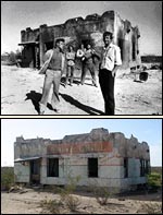
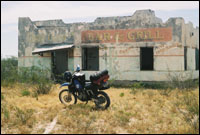
Chata Ortega's Bar &
Grill
Bill Peterson: Just a few
miles west of Pecos Parachute School (and nowhere near the border, despite
Gardner's assertion) is Chata Ortega's. The desolate setting suggests that it
was built as a set, but a peek inside reveals kitchen appliances, restaurant
furniture and other indicators that this was once an actual "Bar and Grill" as
claimed by the sign out front. The front of the building is in pretty good
shape - all of the painting is still visible. But if you want to see Chata
Ortega's, you should do it soon. The entire back of the place is collapsing
(see photo below right) and the front can't be far behind.
Chata Ortega's is located between Toyah
and Pecos on Interstate 20. Take the Shaw Road exit (exit
29), turn west on the feeder road on the south side of the
interstate, and you will see the building about a mile down
on your left (i.e. south of the freeway), about 50 yards
south of the feeder road. Just hop the barbed wire fence
(there's no one around to stop you) and you have the run
of the place. GPS coordinates: N31º 21.047', W103º
42.751'.
Well guys, kind of an anticlimax.....but
Chata Ortega's was nothing more than a small house used
by the migrant workers back when Pecos had so many cotton
and cantaloupe farms. It belonged to John Oates and was
just a small stucco house long abandoned when the cost of
natural gas made it too expensive to irrigate. My wife's
family is from Pecos and it took my sister in law about
an hour to find an old timer that knew the story. Man it's
amazing what some of these old folks remember.....She also
said that they were going to burn down Chata's in the movie
when the Groovers left, but decided it would be too risky
as far as a grass fire etc. and painted the burned area
on instead.
*****VERY IMPORTANT*****
The property has "NO TRESSPASSING"
signs posted. The local sheriff may arrest you for trespassing.
Please email Jeff if you plan to visit and I will get you
permission from one of the owners for a visit.
fandangoJeff |
|
zoom-in
zoom-in
|
|
|
|
Swede: Photos from my
2005
location-hunt road trip. |
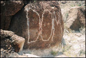
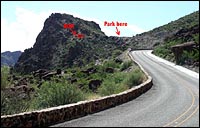
The Dom Rock
Chuck: The Dom Rock is in another location on the
Rio Grande. I'll have to look at some of my old memorabilia to get the
name.
Wade: DOM is located between Lajitas and Presidio
on FM170. It is on the biggest hill on that road with GPS coordinates of
N29.29607 W103.94179.
Karl Leslie: Actually Alex, there is an easier way
to get to Dom without having to rely on GPS: From Ben's Lounge (don't break the
pool cues, they're $25 bucks each), go north on FM170, through Presidio, pass
the state park... once you get to the Tee Pee's, make a 'U wee', go back to the
top of the 'big hill' and park next to the green trash can. Head towards the
river. You can't miss it! I've camped at LaKiva and hiked to the bar, once a
year for the last 5 years. I'm the man in the know when it comes to Big Bend,
Lajitas, Mexican Strange (the donkey lady), etc.
|
Dean Pierce: I'm almost positive the Robert
Rodriguez movie "SPY KIDS 2" used the DOM site for one of it's scenes. It's the
scene where the kids are fighting animated skeletons. The rock where Kevin
Costner threw the champagne bottle from is featured prominently. The rock where
DOM was written has been altered.
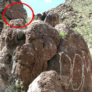
Bill Peterson: The rock is
still there and in fine shape. In fact, there is still a hole at the base where
Gardner dug up the Dom. The first "DOM" inscription, from Kevin Reynold's
college trip, I believe, is still visible as well (but much more faint) on
another rock about 20 feet above the rock used in Fandango (see photo). While I
was visiting, a local showed up and said that this location was a popular vista
long before the Fandango movie. He confirmed that it was the movie crew that
inscribed "DOM" on the rock.
Some of the directions listed on your
site are incorrect. The DOM rock is located between Lajitas
and Presidio on Highway FM170. Specifically, the rock is
13.5 miles north of Lajitas, 1.5 miles north of the rest
area with teepee shaped shelters, and 36.5 miles south of
the Highway 67 intersection in Presidio. It is located on
the highest hill on FM170. Just park your car on the shoulder
(see photo above right), hike about 50 feet toward
the river, and voila - DOM. GPS coordinates: 29°17'45.65"N
103°56'30.27"W . |
|
zoom-in
zoom-in
|
Swede: Photos from my 2005
location-hunt road trip.
Plane/Helicopter chase scene
Got this today....great story Thanks, Joel
Hi,
I ran across your great “Fandango” site while trying
to place the “Giant” mansion remnants in an attempt
to locate them via Google Earth. In doing so, I also checked out
your on “Fandango’s” location info and I thought
you might find this interesting.
The plane/helicopter chase scene was, indeed, filmed in Tulsa,
OK, and I say this only because I was a member of the local stagehands
union (IATSE Local 354) and was recruited as an “extra”
crew member to augment the Hollywood guys for this filming sequence.
We worked only one day, a Saturday, and the filming was completed
in a single take as the intersecting highways had to be temporarily
closed during the sequence. The specific location was the intersection
of Highway 169 and US412/I-244 on the northeast side of Tulsa
and just southeast of Tulsa International Airport.
I was selected to work as a gaffer on the shoot and assisted
in digging out and camouflaging a camera location, which sat immediately
adjacent to the westbound I-244 lanes and looked east, in a position
to film the aircraft approaching the overpass. After locating
a camera position and digging out the underbrush and grass to
create a flat position, I was instructed to cut down a small tree
underneath the overpass, remove individual branches and return
up the embankment to create a foliage blind for the camera. At
the same time, another gaffer was stretching out a brightly colored
plastic tape (similar to crime scene tape), to create an east-west
alignment line, which the aircraft and helicopter pilots could
use to guide them underneath the underpass. Shortly thereafter
the highways were shut down and were immediately followed by a
“rehearsal” run and moments later, the actual run
itself. I seem to recall this took around 15 minutes.
I have attached an overview from Google Maps, which I have added
to provide some clarity on the location. The red line denotes
the flight path underneath the overpass and my particular camera
position is marked with a yellow asterisk. I should note that
for obvious reasons, there were, as I recall, 1 or 2 other camera
positions but I cannot recall where they were.
I will add that following filming, we were bused to lunch at
a nearby La Quinta motel, where we were served an unforgettable
buffet-style lunch. (This is common on movie shoots as craft services
folks take very good care of the Hollywood and local crews!) While
I do not specifically recall what it was to be, some additional
scenes were scheduled in the afternoon and were to be shot in
the general area. However shortly before our call back time, a
really nasty severe thunderstorm formed, which nixed further shooting
for the day.
.jpg)
Chip Ellsworth: The scene where Truman goes to pickup
Suzy Amis's character in "Dallas" was actual shot in Tulsa, OK.
My father-in-law used to own a helicopter company in Stroud, OK
and the film crew leased one of his helicopters for the chase
scene. This helicopter was actually red and white, but they used
tape to make it blue and white for the movie. My father-in-law
said he thought that Truman's airplane belonged to Kevin Reynolds
or was given to him after the movie.
As most of you know, the Truman Picks Up The Girl scene was filmed
in Tulsa because Texas would not allow the scene on the Dallas
highways.....
The street in Tulsa where the plane lands
I grew up on that street and remember the doorbell ringing to
let us know a plane was going to land on it! It is Forest Blvd.,
74114. A new owner bought the house, erected a big fence and made
changes, but most of the front of the house is the same.
Many Thanks to:
Michele S. Efron
Tulsa
House Today
Truman drops off the girl
Swede: I found (by happenstance) the rest area where Truman
drops the girl off for the wedding. Though the buildings are no
longer there, the mountains and ditch in the background give it
away. It is off of Texas Hwy 20, between Fort Hancock and San
Elizario. Google earth co-ordinates 31°23'10.96"N 105°58'55.78"W
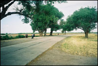
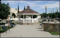
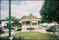
The Gazebo (the Wedding Scene)
Chuck 'Dorman' Bush: The gazebo is
located in the center of San Elizario, Texas near El Paso so it shouldn't be
too hard for you to locate. This gazebo was already there when we came to town,
but our construction guys made some additions. Two dear friends of mine were
married in that same gazebo during the filming of Fandango: he was our First
Aid Tech, Todd Adelman.
Todd J. Adelman: I'm the guy that
actually was married in the gazebo in San Elizario, Texas. Nancy and I are
still married and we live in Oregon, where we have a ranch and a 15 year old
son. We plan to go back to San Elizario in June 2003 (we were married on the
2nd at 2 am) to celebrate our 20th anniversary. I wouldn't have believed there
would be a Fandango site! Of course, every time it is on I have to watch it
again also! Take care. Hi to Chuck, Brian, the Kevins and all you other
Groovers.
|
Bill Peterson: The San
Elizario town square where the wedding took place has received a major
facelift. The gazebo has been completely rebuilt, most of the big trees were
removed, the benches were replaced, and an enormous historical marker was
erected. I met Ben Sanchez, the curator of the local museum, and he said that
the renovations were done in the early 1990's. Ben told me that the phone that
was used in the scene was just a prop. I could not find the road where Truman
landed with the bride. |
|
zoom-in
|
Ben, a lifelong San Elizario resident, did not recognize
the scene at all (I showed him a still picture I captured from the tape), so I
suppose it was shot elsewhere. The gazebo is easy to find - take Interstate 10
about 15 miles east of El Paso, use exit 42, and follow the signs to San
Elizario (about 5 miles south of the freeway). GPS coordinates: N31º
35.094', W106º 16.398'.
|
|
|
Swede: Photos from my
2005
location-hunt road trip. |
________________________________________________________________________________
TRAIN/WATER SKI "WE ARE ALL GONNA DIE"
The Train/Water skiing site is as close as I can get from the
directions Hal has given me.
Google Earth Co-ordinates are 31°48'6.44"N 104°
4'33.94"W
Sorry....no pictures yet JEFF
|